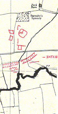
Settlement enclosure/ Kings Newnham Site A
The site of a settlement, possibly of Iron Age or Romano-British date. It is visible as a series of cropmarks on aerial photographs. The settlement is situated 800m north west of Newnham Hall.
1 Undated settlement, consisting of a subrectangular enclosure and linear features, shows on aerial photographs.
2 In advance of the laying of a gas pipeline, a 20m wide section of the site was archaeologically investigated. The excavation located the enclosure ditch of a small sub-rectangular enclosure with a southern entrance and extension on the east side. The west side had been truncated by Post Medieval quarrying, which had removed up to 50% of the original extent of the enclosure at that point. Six small pits were located in the interior, each containing heat-cracked pebbles. Only the largest pit produced evidence of burning, together with a quantity of daub and burnt clay. No other features had survived within this section of the enclosure and only one small pit and two small postholes were located outside it.
3 Interim report of the above excavation. The site is provisionally interpreted as a small agricultural settlement dated by form to the Iron Age, though no dating evidence was recovered. A former stream course was revealed by excavation, and is thought to have influenced the location of the settlement. Two phases of construction of this particular enclosure are outlined, with its function in each phase apparently being to enclose domestic storage pits. Both phases were cut by a later ditch containing Iron Age pottery. Later disturbance has been caused by localised quarrying (the field is named “Sandpit Close” on a map of 1720), by repeated ploughing and by a previous pipeline through the site. Evidence of quarrying and the previous pipeline shows on the aerial photographs.
4 1999 pipeline excavations to the north of the cropmark revealed a few short lengths of gully which were not directly datable but their alignemnt with the cropmark enclosure to the south suggests that they are likely to belong to the same phase.
5 1999 pipeline excavations revealed a pit cluster probably relating to cropmark enclosure. The majority of the pits however remain undated although the presence of iron hammerscale and slag suggests that many of them could be Iron Age or more likely later. Two groups of pits may have held posts, but in no case were post-pipes evident and no structures could be recognised. Two undated gullies were also recovered at the northern end of the site.
6 A subrectangular enclosure and linear feature showing on aerial photographs were mapped as part of the English Heritage National Mapping Project.
- For the sources of these notes, see the
- Timetrail record
- produced by the Historic Environment Record.


Comments
Add a comment about this page