Snitterfield Medieval Settlement
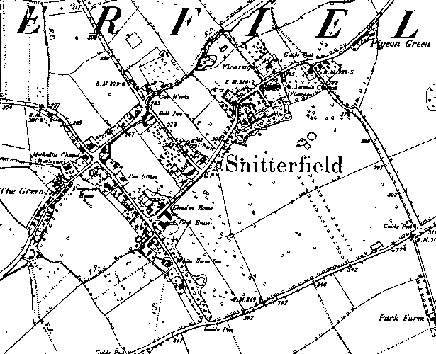
The possible extent of the Medieval settlement of Snitterfield. The area of settlement is suggested by Greenwoods map of 1822 and the Ordnance Survey map of 1886.
1 The possible extent of Medieval settlement, based on the first edition 6″ map, and on Greenwood’s map of 1822.
2 The Manor passed from the Catilupe family to Thomas West and Eleanor. Market Charter granted for Wednesdays on 24th September 1257 by Henry III to John de Cantilupo. Market Charter granted for Tuesdays on 7th May 1324 by Edward II to Thomas West and Eleanor, his wife. To be held at Manor. Fair for vigil feast morrow of Kenelm (17th July) granted 24th September 1257 by Henry III to John de Cantilupo. On 7th May 1324 Edward II granted Thomas West and His wife Eleanor a fair on vigil feast+6 Kenelm at the manor.
3 Domesday lists Snitterfield in Ferncombe Hundred. The Phillimore edition has a grid reference of 21,60, which differs slightly from this grid ref of 21,59. Ref 16,15 (Land of the Count of Meulan) Saxi held it ; he was a free man. 4 hides. Land for 14 ploughs. In lordship 2; 10 slaves. 11 villagers with a priest and 4 smallholders have 6 ploughs. Meadow, 12 acres. Value before 1066 and later £4; now 100s.
4 The 1886 map shows a very dispersed village, possibly with two centres, one round the church, and one further west at the crossroads, where there is settlement along the 4 arms of the intersection. The map is covered with post medieval names of houses, pubs, post office, gas works and some formal gaardens, which suggests that the village may have undergone a lot of change. The central rectangle is included, although it is hard to tell how much settlement was there. Domesday indicates quite a valuable settlement. There is no ridge and furrow plotting for the parish, but the database shows some suvival abutting the village to the southeast, and a detatched area further north.
5 The medeival extent has been altered slightly to reflect lidar imagery. Few earthworks survive, most being covered by later development. However a few house plots, probably medeival, are located at the northern tip of the possible extent and include narrow plots to their rear.
- For the sources of these notes, see the
- Timetrail record
- produced by the Historic Environment Record.


Comments
Add a comment about this page