Excav of Iron Age Sett'mt 600m SW of Brandon Wd Fm
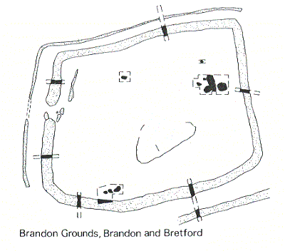
Aerial photographs showed evidence of a double ditched enclosure and a linear feature. The site was part excavated prior to gravel extraction. Iron Age pits and post holes were uncovered. The site is 400m northeast of Brandon Marsh Nature Reserve.
1 Air photograph.
2 Subrectangular double-ditched enclosure with associated linear feature shows on air photograph.
3 The site lies on Baginton-Lillington gravels. A salvage excavation was mounted in 1970 in advance of destruction by gravel-quarrying. Sections were cut across the enclosure at six points and a number of internal features examined. The enclosure is about 0.69 ha with an entrance to the W. The ditch was 3.7m to 5.8m wide and 1.5m to 2m deep. In addition four areas were opened inside the enclosure. Area A produced three pits, a post hole and a ditch; Area B produced three pits, a gully and a post hole; Area C produced a pit and area D a number of pits and post holes. The main phase is Iron Age, although there was also evidence of Anglo Saxon settlement (PRN 5653). Finds include four halves of rotary querns and a fragment of (hand) rotary quern, a fragment of triangular clay loomweight, hand-made pottery in ‘sandy’ fabrics.
4 A double-ditched subrectangular enclosure mapped from aerial photography as part of the English Heritage (EH) National Mapping Project (NMP) A fainter rectangular enclosure was also evident 130m to the north east of the double-ditched feature.
5 Field record sheet. Site visit undertaked as gravel extraction being extended west. Possible ditch complex observed and find of ?Samain ware lid was reported.
- For the sources of these notes, see the
- Timetrail record
- produced by the Historic Environment Record.


Comments
Add a comment about this page