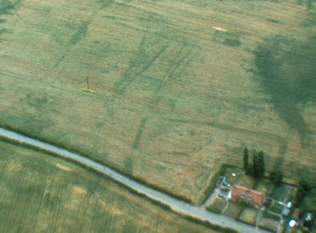
Site of Settlement 200m E of Hatton Rock Farm
Aerial photographs show a complex of various enclosures, pits, gullies and linear features. Their date is uncertain, but they may be Iron Age or Roman and they may represent the remains of a settlement. They are located at Hatton Rock.
1 Complex cropmark site.
4 Air photographs show a complex of enclosures including at least three rectangular/subrectangular enclosures, a number of scatters of pits, penannular gullies, other possible enclosures and linear features. A pit alignment (PRN 6265) cuts across the site. The site is undated, but on morphological grounds may be Iron Age and Romano British.
5 A fairly large complex of rectilinear enclosures, criss-crossed by trackways, with a very interesting group of ring ditches surrounded by enclosure at NW of site.
6 SAM List.
7 Plan of scheduled area.
8 Observation at 7 Hatton Rock recorded the NW corner of the large enclosure visible towards the NW of the cropmark complex, referred to in 5. Unfortunately, no dating evidence was recovered from the ditch fill, although an Iron Age date for the enclosure, and the roundhouses (and pits and linear features) within it is suggested as most likely.
- For the sources of these notes, see the
- Timetrail record
- produced by the Historic Environment Record.


Comments
Add a comment about this page