Possible Roman settlement
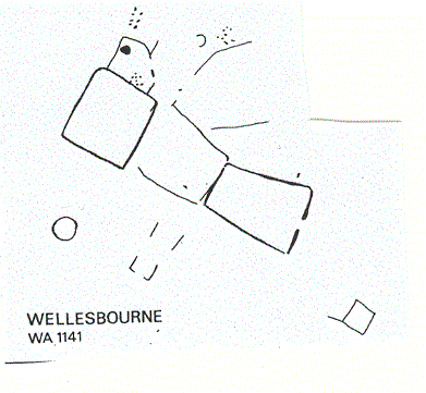
Enclosures are visible as cropmarks on aerial photographs. The site was excavated prior to development. Ditches, pits, a semi-circular feature, and some occupational debris were found, suggesting a rural settlement of Roman date. It was situated 300m east of Hail End Bridge.
1 Excavations carried out in 1967 on site threatened by gravel extraction. The site shows on aerial photographs as a series of intersecting rectangular enclosures covering about 3.7 ha. An area of about 30 by 30m was opened up and trenches cut to establish chronology and layout. There appear to have been three closely related periods dated by pottery in ditches from the end of 1st century AD to the beginning of 3rd century. No traces of buildings were found in the area under excavation apart from a quantity of burnt stone in the ditches which may have supported a timber construction in this loose soil. The ditches were in most cases V-shaped and some appear to have supported timbers which were subsequently removed. There were no finds except pottery, leading to the conclusion that this was a poor settlement of early Roman date having a comparatively short period of existence.
2 Initially two 0.9m trenches were cut at right angles to each other to locate crop marks. The first trench revealed a single ditch with early Romano British pottery at its W end. The second trench ran N-S and revealed a series of ditches. An area 20 x 25m was cleared mechanically and ditches were excavated to examine construction, dating evidence and sequence. A S double ditch was found and traced outside the stripped area by trenching. At its W end this joined with the N-S ditch found in Trench 1. Another double ditch was found to the N of this ditch. The N ditch of this double ditch had a trench cut into its lip, which may have held timbers for a revettment. This double ditch was part of an enclosure, two sides of which were located and the enclosure shown to be about 21 x 21m. Two further enclosures were examined. A large circular shallow ditch, a drainage ditch, various pits and a semicircular feature were found. The following sequence is suggested: 1. Prehistoric (Bronze Age?) – a small ditch to the N of the site with sherds and flints (PRN 5169). 2. Romano British – the circular and semicircular feature. Diameter of circular feature at 18m is too large for a house and it may have been a stockade for animals. 3. A double ditched enclosure 21 by 21m. 4. A single ditch and double ditch at right angles to each other cut across the site. The life of the complex was probably quite short. Some possible 1st century pottery and also 2nd to 3rd century pottery was recovered. Also a small quantity of animal bone, burnt clay, burnt stone and one fragment of quern stone. The site appears to have been a poor rural settlement of 2nd to 3rd century date.
3 Part of an extensive cropmark site north of Thelsford Brook. Southern enclosure removed by gravel quarrying. Worked flint found beside trackway.
- For the sources of these notes, see the
- Timetrail record
- produced by the Historic Environment Record.


Comments
Add a comment about this page