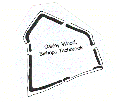
Oakley Wood Camp
Oakley Wood Camp, the possible site of an Iron Age hillfort. Substantial banks are visible as earthworks within the wood. An alternative suggestion is that the banks are connected to the management of the woodland. The site is located 1km north of Ashorne Hill.
1 An entrenchment in good preservation and of considerable size. It is on fairly level ground. The camp, roughly triangular in form, encloses an area of about 3.75 ha. The defences, which are still formidable on the N side, consist primarily of a rampart, protected externally by a ditch; beyond this again are remnants in some places of a second rampart and ditch. There are further banks and trenches to be seen within the wood, which probably formed outworks to the main fort. The height of the ramparts at the N apex is 3.9m, with a breadth at its base of 8.8m; the ditch defending it measures 10.5m across.
2 1956. The wood has been cleared and the site replanted recently. A possible entrance was noted. At the SE corner and middle of the W side the defences are joined by boundary banks. At the latter point the rampart has been breached by the N ditch of the boundary bank, which is plainly later than the main work. 1969. This is a plateau fort. In construction the defences are typically Iron Age, with probable original entrances at E and W. No trace of outworks or outer rampart.
5 Banks and ditches are distinct and of considerable size. W sector: Bank 1.5m above dry ditch and interior. NW sector: Bank c2m above silty ditch, terminating at N apex in a mound c2.5m high. NE and E sectors: Banks much slighter, c0.75m above dry ditch. Small entrance halfway along E sector. SE corner: Bank discontinues here. Line of S bank continues E towards edge of wood.
6 The shape, location and structure of the earthwork are fairly anomalous. Although on top of a plateau the location is not obviously defensive. The shape is irregular rectilinear, unlike other Warwickshire hillforts, which are oval or rectangular. The ‘hillfort’ is part of a complex of ditched and banked enclosures in and surrounding Oakley Wood. Each of the sharp corners of the ‘hillfort’ has an earthwork leading off towards a boundary earthwork that surrounds the wood. It seems possible that the whole complex, including the ‘hillfort’, is related to Medieval woodland management.
7 Field survey form suggests the site is possibly not a hillfort. A field visit indicated that the site is part of a complex of ditched and banked earthworks in and surrounding Oakley Wood. Described as above.
8 Dating revised to between the Late Bronze Age and the Late Iron Age.
9 Undated plan.
10 Correspondence from 1997 about damage to the site.
11 Details of name and telephone number of the Forest Manager of the Wood.
- For the sources of these notes, see the
- Timetrail record
- produced by the Historic Environment Record.


Comments
Add a comment about this page