Site of Studley Priory Moat
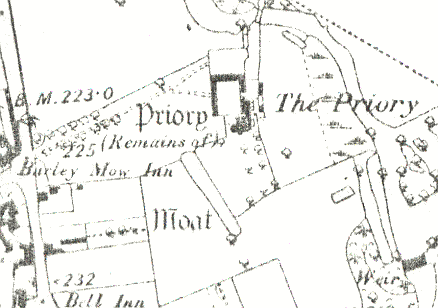
The site of a Medieval moat, a wide ditch usually surrounding a building. It was associated with Studley Priory, but has now been filled in. It was located 100m north east of the Police Station at Studley.
1 Studley Priory stands in a moated enclosure, the River Arrow forming part of it, and supplying the other portion with water, where not filled in.
2 A dry channel continuing N from the pond published as a moat was filled two years ago and the destruction of the remainder is imminent.
3 The configuration of two linear ponds which have been completely filled in suggests that a watercourse may have led around the site of the Priory, from a bend in the River Arrow to the N, along a field boundary to the W, into a large rectangular pond and then NE through a second pond to rejoin the River Arrow. A linear pond on the W side has now been filled in and irregularities on the ground today are quite unrelated.
4This moat is shown as an ‘L’ shape on the 1 inch to 1 mile OS map of circa 1834. It is fairly clear that it marks the south-west corner of the priory precinct, possibly the inner precinct.
- For the sources of these notes, see the
- Timetrail record
- produced by the Historic Environment Record.


Comments
Add a comment about this page