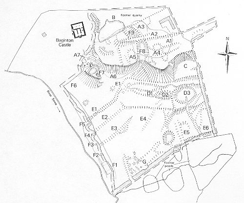
Site of Shrunken Medieval Settlement
The site of a Medieval shrunken village. The remains of house platforms and a hollow way are visible as earthworks. The site is located to the east of Baginton Castle.
1 During the excavation of the castle trial holes were dug at various likely places without producing evidence for other buildings. There were however traces of buildings between the church and the castle. Foundations of a large building, mainly of dry-coursed stone, were found extending over a large area, with many broken roof-tiles. The building appears to have been a wooden one on stone foundations, but was destroyed by gravel digging before a complete survey could be made.
2 Various Medieval features were observed in the section of the gravel pit which extends from the Castle to the Church. At the E end traces of a building (d) were traced resting on a layer which produced 13th century pottery. A second possible Medieval building (c) and a third which was associated with a ditch (dd) produced pottery. Traces of a road were found close by and pottery, tile, bone, an arrowhead and a silver penny of Richard II found. A fourth building (a) had stone foundations and a ceramic tile roof and was associated with 14th century and 15th century pottery. Medieval pottery has been brought to the writer from wasteland S of the church between the Stoneleigh footpath and the field. It is plain that evidence for Medieval Baginton should be sought SE and SW of the church.
3 Scheduled as ‘an area of house platforms’ between the castle and the church.
4 Shrunken settlement remains surveyed, associated remains include a terrace and a series of drainage gullies, presumably connected with the Medieval settlement. Components of the site include: a continuation of the main east west street as a hollow way, a probable boundary bank, building/house platforms and a terrace which seems likely to have been the Medieval road to the castle.
5 Scheduling amended in 1994.
6 Scheduling record from 1980.
7 Extended area scheduled 1982.
- For the sources of these notes, see the
- Timetrail record
- produced by the Historic Environment Record.


Comments
Add a comment about this page