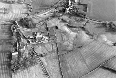
Tidmington Medieval Settlement
Probable extent of Medieval settlement in Tidmington as indicated on the Ordnance Survey map of 1886 and from ridge and furrow earthworks on aerial photographs.
1The possible extent of Medieval settlement, based on the first edition 6″ map of 1886, 53SE.
2The ridge and furrow plotting of the parish.
3 Domesday lists Tidmington under Worcestershire, in Oswaldslow Hundred, ref EW1. It is recorded as a ‘member’ of Tredington, and so, presumably, a lesser settlement. See the VCH for a discussion on this point.
4 The first edition map shows a dispersed village, with the church to the north, and the settlement, which is only hamlet size, mostly around the lane leading west. The ridge and furrow plotting of the parish shows almost complete survival around the village to the west, together with earthworks, which represent shrunken settlement WA2105. The church [WA2105] dates from the C13th.
- For the sources of these notes, see the
- Timetrail record
- produced by the Historic Environment Record.


Comments
Add a comment about this page