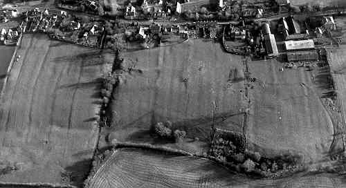
Shrunken Medieval Settlement 300m SW of Church, Ufton
Description of this historic site
The site of a deserted settlement dating to the Medieval period. The site has been identified from the earthworks of two hollow ways and several possible house platforms. It is located 300m south west of the church, Ufton.
Can you help?
Notes about this historic site
1 Possible house platforms can be discerned at the top and the bottom of the hill on either side of an unusually pronounced hollow way running down the hill from SP3761 to SP3762, the banks of which are about 1.7m in height. A second hollow way joining the major one from the NE is apparent at the bottom of the hill at SP3762. To the S of this is a possible fish pond (PRN 6223).
- For the sources of these notes, see the
- Timetrail record
- produced by the Historic Environment Record.


Comments
Add a comment about this page