Nadbury Camp
Nadbury Camp, an Iron Age hillfort. In some areas the ramparts are still visible as earthworks. The hillfort is located 400m south of Arlescote.
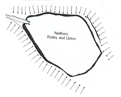
1 Remains of an extensive earthwork located on a jutting promontory of Edge Hill at about 230m. It has a very commanding position on top of a steep escarpment. Land falls steeply to the S and W, where a little stream runs in the bottom of a valley. The stronghold is pear-shaped with pointed end to the W. Encloses 7 ha. The earthworks are very denuded. A plan of 1822 shows a double rampart with intervening ditch. The single entrance, at the W end, is approached by a hollow way. This was crossed at a later date by the modern road which runs along the N ditch.
2 Still in good condition although ploughed for many years. The counterscarp shown on the 1822 plan has been almost completely ploughed out. APs reveal an extension (annex or earlier phase) to the SE. This cannot be traced on the ground. A ‘beehive’ quern was found c1960 at SP3848.
6 Interior is divided into two arable fields. Ramparts are marked by breaks of slope on all sides. On the N the road appears to be cut into the defensive ditch. To the NE there are slight traces of an outer bank. A survey produced seventy fragments of Iron Age pot and also other finds.
7 Small excavation in 1983 in advance of road widening on N of camp. Rampart appears to be of dump construction with a rear revetment of large stones. The front face was damaged by a large quarry pit. An earlier phase was represented by a pit sealed by the rampart and a later phase by a pit containing a currency bar cut into the back of the rampart. The trench produced bone, pottery and slag from all phases. A resistivity survey of part of the interior indicated considerable activity.
8 No evidence of a ditch.
9 SAM List.
10 Mention.
11 Mention.
12 Archaeological observations took place in 1997 and 1998 in connection with water mains work. In 1997 seven launch/ reception pits did not reveal any Iron Age or Romano-British archaeological remains, although a small amount of modern material was recovered. In 1998 the digging of a pipe trench and test pits within the Scheduled area was archaeologically monitored. Again, no significant remains were encountered. All the works took place within the roadway of Camp Lane, and a considerable depth of resurfacing material was encountered in places.
13 Field walking by Edgehill Group in 1999 recovered an assemblage of predominently Early Iron Age Pottery together with flint from several different time periods.
14 Letters relating to the field survey in 13.
15 Early scheduling information.
16 Letter from EH to the effect that the road was no longer to be included in the scheduled area.
17 Archival material relating to a threat of mining in the 1950s.
18 Detailed personal comments on the excavation report of C. McArthur.
19 Letter from 1972 reporting ploughing of the ramparts.
20 Letter from 1974 about ploughing.
21 Letter from Alan French in 1981 about progress of work at the Camp.
22 Letter from WM to Alan French in 1982.
23 Letters from 1983 from Birmingham University about their work at the Camp.
24 Short report dated 1983 of an evaluation at the Camp.
25 OS map of Ratley and Upton 1922.
26 Undated plan.
27 Undated map with key. Probably from soon after the Public Enquiry of 1954.
28 Plan from 1996 showing proposed new water main within the road of Camp Lane.
29 Letter from 1987 with comments on report about Iron Age pottery found.
30 Handwritten notes, probably in relation to a planning application.
31 Letter from WM with information to a member of the public.
32 Material in connection to the proposed new water main along Camp Lane. See also 28.
- For the sources of these notes, see the
- Timetrail record
- produced by the Historic Environment Record.


Comments
Add a comment about this page