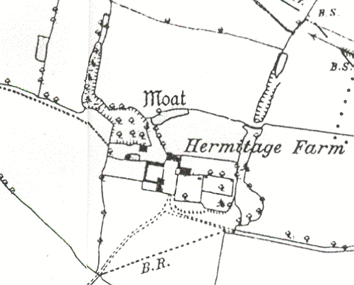
Moat at Hermitage Farm, Little Packington.
The site of a moat, a wide ditch surrounding a building, which is Medieval in date. It is visible as an earthwork and is situated 100m north of Hermitage Farm.
1 Hermitage Farm is an early C18 brick house enclosed by the remains of a rectangular moat. SE of the house, within the moat, are the foundations of a large rectangular building, probably medieval, about 36m long, which had walls of mud. A small portion of the NE angle stands a few feet high, adapted for other purposes. A hermitage is said to have been built in Little Packington parish by Hemeric, incumbent temp. Henry I.
2 1967: A large deep homestead moat partially surrounding Hermitage Farm. Adjacent to the N is a larger and stronger defensive moat that gives the impression of never having been completed, there being no ground evidence for the original N arm. In all cases the earthworks are impressive and in one instance achieve a maximum depth of 5m. No building foundations were identified in the dense undergrowth to the SE of the farm. The occupier was not available for consulting. This is possibly the site of the Hermitage but the size and spread of the remaining earthworks also suggest later occupation. 1976: The S and W arms of the moat have been filled in. The N arm is being reduced and encroached upon by ploughing. The steep-sided E arm averages 12m in width and 3m depth. The building foundations recorded above probably refer to a rectangular enclosure which is bounded by low banks of packed clay. The large moated enclosure to the N measures 210m E-W and was at least 120m N-S, but there are no traces of a N arm. The steep-sided E and W arms, which are partially waterfilled, average 14m in width and are from 3-5m deep. The water for the moat came from surface drainage.
4 Condition unchanged.
5 Plan in relation to a proposed change of use in 1992.
- For the sources of these notes, see the
- Timetrail record
- produced by the Historic Environment Record.


Comments
Add a comment about this page