
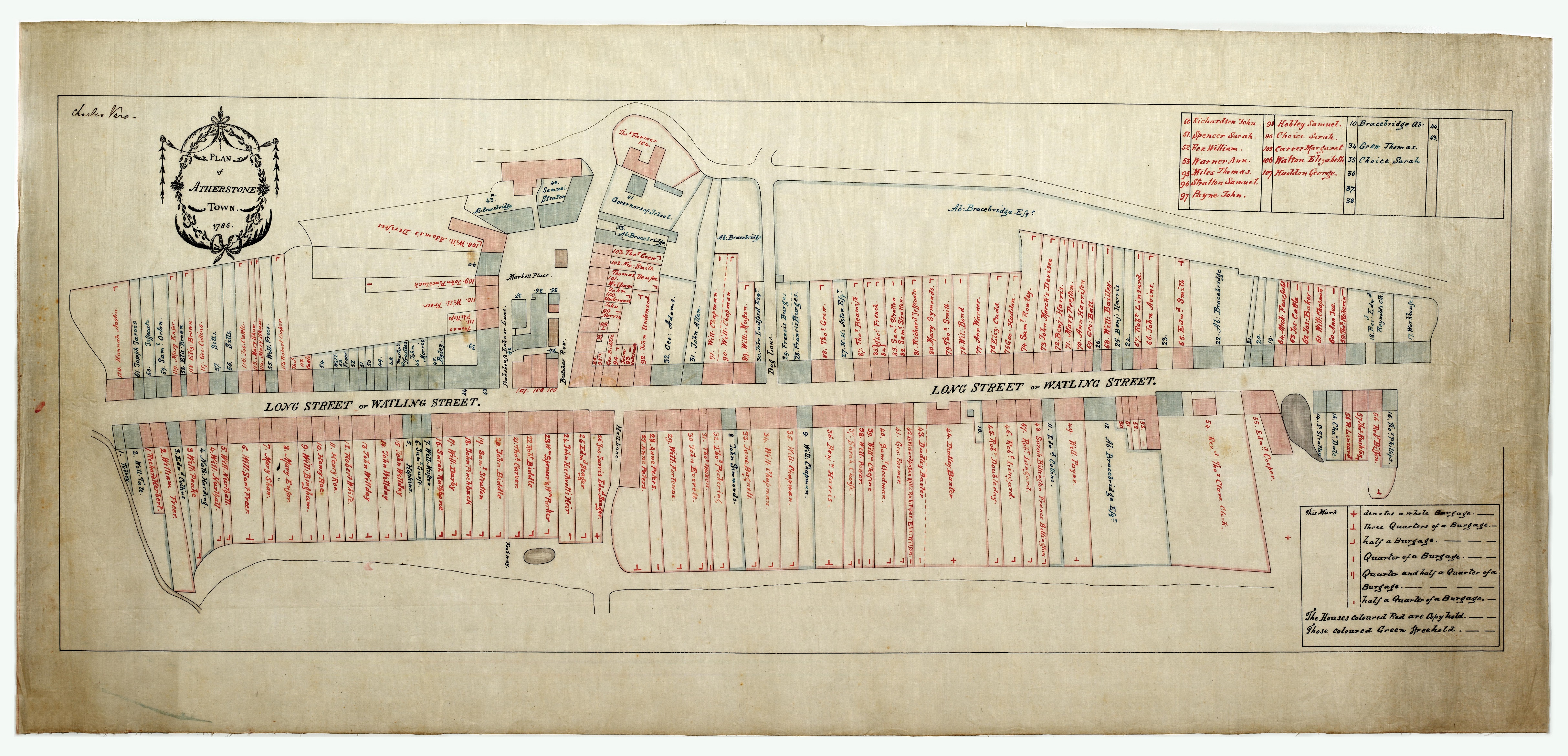
Each burgage plot is identified by the code it was given on the 1786 plan, i.e. ‘F1’ for the first freehold burgage and ‘C1’ for the first copyhold, starting at the west end of Long Street on the south-west side. Where possible, the modern street number is also given and an indication as to whether the building has been demolished1.
The individual histories are collected into 20 files, arranged by reference number and location. Note that that the reference numbers were created for the 1786 plan, the earliest plan showing the detailed layout of the town2.
Finding a House History
Look at the Files Index for the file containing this plot number or street address. For a plot number you can also identify the corresponding file from the block diagram.
See the Overview File for an explanation of how the Histories were compiled and the Abbreviations and References Files for additional information and explanations.
Guide to using the House Histories
- Page: This is the page or folio of the document where the reference can be found. ‘v’ indicates it is on the reverse of the sheet; a letter of alphabet also used occasionally.
- Date: This is the date of the document. Note that until 1751 a new year began on 25 March and not on 1 January. The dates shown are as on the document; therefore ‘16 Mar 1725’ would today be written as ‘16 Mar 1726.’
- Entry: This is a précis of the source document and although care has been taken in transcription, there may be occasional mistakes. Until the eighteenth century most documents were written in Latin and therefore the entry is usually a translation. This was not classical Latin and tends to be very formulaic.
- Names of tenants are not always given in the original sources, especially for the early period.
- Occupant: This is either the owner or his/her tenant(s).
- Abuttals: A property immediately neighbouring another property on either side. ‘(W)’ indicates the west side of the property. It has been surmised that the first abuttal was usually on the right of the property and the second on the left, (when facing the front), but this is by no means universal and cannot be regarded as a rule.
- Square brackets indicate that the entry is provisional and may be misplaced.
Please follow this link to view the Atherstone House History Project in entirety.
1 If users have any corrections or additions to make to the project, please add a comment on the relevant page.
2 However, earlier configurations of plots may have been different. All we can say for certain it that although plots were subdivided throughout the period from 1547, the boundaries between them generally remained unchanged.


Comments
Add a comment about this page