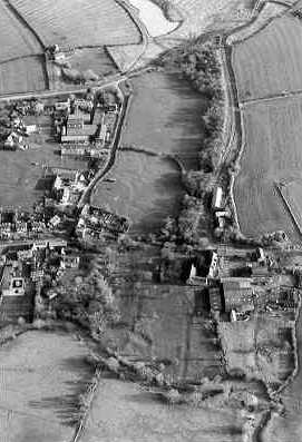
Possible Shrunken Medieval Settlement at Willington
The site of a possible shrunken village, at Willington, dating to the Medieval period. The remains of the village are visible as earthworks on aerial photographs. The village is also mentioned in documentary evidence.
1 Rous lists depopulation here, but although the parish village of Barcheston suffered at the hands of William Willington, Willington does not appear in the 1517 Inquiry. It is still a compact hamlet, although the aerial photographs show that like many villages it has been larger.
2 Surface evidence of former habitation is limited to the confines of the modern village.
3 Domesday lists Willington in Barcheston Hundred. The Phillimore edition has a grid reference of 26,39.
Ref 22,15 Ewein holds 1 1/2 hides in Willington. Land for 2 ploughs. In lordship 1; 2 slaves, with 1 villager and 1 smallholder. The value was and is 20s. Doda and Leofric held it freely.
Ref 32,1 Gilbert of Ghent holds from the King 1 hide and 1 1/2 virgates of land in Willington, and Fulbric from him. Land for 1 plough. A mill at 5s; meadow, 15 acres. The value was, and is 20s. Alfward held it freely.
4 An area of medieval settlement is visible as earthworks on aerial photographs. The site comprises at least four building platforms, four hollow ways, a probable croft and a possible pond. The possible building platforms measure between 30×25 metres and 17×12 metres. One of the hollow ways have been levelled on aerial photographs taken in 2007. One is partially enclosed by a croft defined by boundary banks. A possible pond is defined by an oval hollow surrounded by spoil heaps. This site has been mapped from aerial photographs as part of the South East Warwickshire and Cotswolds HLS Target Areas National Mapping Programme.
- For the sources of these notes, see the
- Timetrail record
- produced by the Historic Environment Record.


Comments
Add a comment about this page