


Manuscript maps can offer a window into past landscapes and tithe maps are often one of the earliest detailed maps you might find for a parish. As well as showing a snapshot of roads, fields, rivers and buildings, tithe maps, and the apportionment books that go with them, can provide a glimpse of a local community through land ownership, land use and local custom and practice.
Where tithe maps come from
Before the mid 19th century, many people paid a tithe (or tenth) of their produce to support the local church, often in the form of a ‘payment in kind’ (crops or livestock) which might be stored in a local tithe barn. By the early 19th century this type of payment was unpopular with many people, both for economic and religious reasons. This eventually led to the Tithe Commutation Act of 1836 which aimed to replace payments in kind with a money payment which would change according to the value of staples such as barley, wheat and oats.
The tithe maps and apportionments (the written schedule which went with the maps) were produced to assess the value of tithes within a parish and to set a fair rent-charge on each piece of titheable land. Together they record the size and arrangement of fields, who owned and occupied land, how it was used and what it was worth.
Warwickshire’s tithe maps
In parts of Warwickshire, tithes had already been commuted, often when the open fields were enclosed, and so tithe maps were created for around two thirds of Warwickshire’s parishes. Very few of the maps created were stamped as ‘first class’ maps. Despite this, tithe maps and apportionments contain a wealth of information which can be useful to family and local historians alike.
Uses
All tithe maps will mark the field boundaries in a parish (or at least for the parts of the parish where tithes were payable), and each parcel of land will be numbered, linking the map with the apportionment. In addition, most tithe maps will show many other features to a greater or lesser extent, including roads, water and buildings. The tithe map alone can be a great tool to see how an area has developed since the mid nineteenth century by comparing it to later maps. Combined with the information from the apportionment, they can help illustrate an ancestors property and wealth, chart land ownership and use across a parish or give a snapshot of the local economy.
Land use and occupation
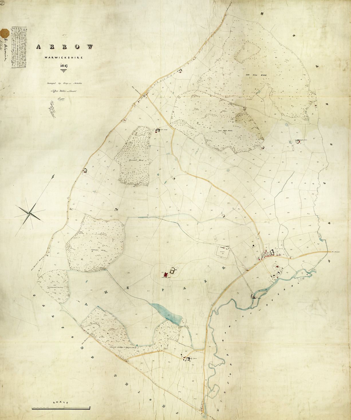
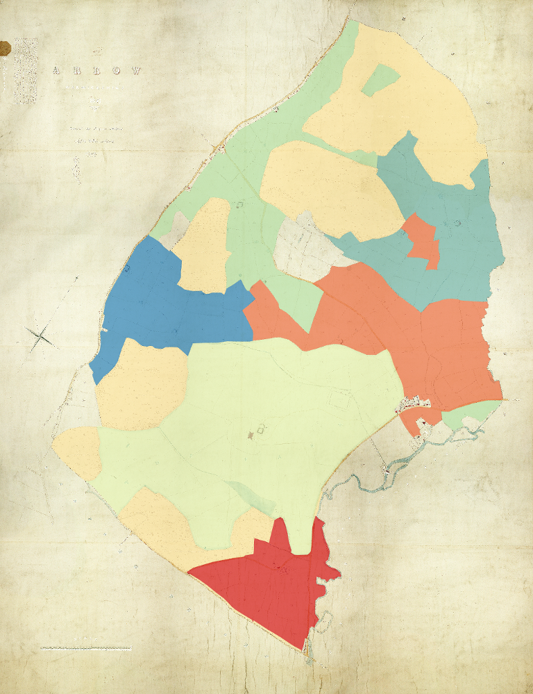
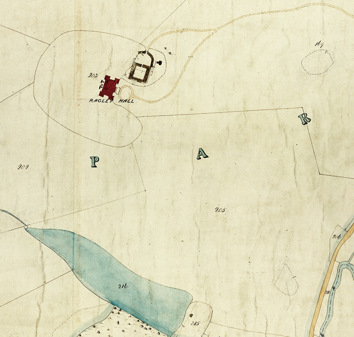
The tithe apportionment for the parish of Arrow records the fact that all the land in the parish was owned by the Marquis of Hertford. Plotting the occupiers of the land on the map, it quickly becomes clear that the majority of the land is held by six men: the Marquis of Hertford (yellow), William Chattaway (orange), John Stephens (blue), Benjamin Proctor (green), John Gilbert (dark blue) and the enigmatically named ‘Beyzen’ (red). All of the wooded land is owned and occupied by the Marquis of Hertford while the remaining occupiers hold fairly compact parcels of land centred around a farm house.
This, however, leaves a large void around Ragley Hall itself (light green), and it is only by systematically working through the apportionment (which is sorted by occupier, not plot number) that it is possible to see that many plot numbers are not included in the apportionment. These missing numbers neatly correspond to the land marked as park on the map and bordered by a faint blue land. The only reference to these plots is a brief note at the end of the apportionment:
The remaining Lands of the District not inserted in this apportionment are with the consent of the Rector specially released from payment of any portion of the Rent Charge.
Expanding on the Census
Although the apportionments only mention the head of a household, they can be used together with census returns from a similar period to flesh out the details and create a fuller picture, where a clear link can be made between the two. It is worth noting that there may have been some time between gathering the information for the apportionment and creating the final document. It may not be safe to assume that the information contained in an apportionment was correct on the date it was signed or stamped, as land could have changed hands without a revision being necessary.
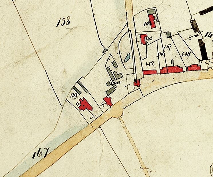
Nonetheless, the Michael Griffiths listed as a Licensed Victualler in Arrow on the the 1851 census with his Wife and two sons is likely to be the same Michael Griffiths listed in the tithe apportionment occupying the Rose and Crown with workshop and gardens comprising three roods and 34 perches, allowing you to establish where the pub was and the extent of its land.
Warwickshire’s tithe maps can be found under references CR 569 and CR 328 on Warwickshire’s Past Unlocked and in the Warwickshire County Record Office searchroom. A key to the maps is available through Compass and a database to the tithe apportionments is available online. Digitised versions of Warwickshire’s tithe maps are also available to purchase in a variety of formats.


Comments
Add a comment about this page