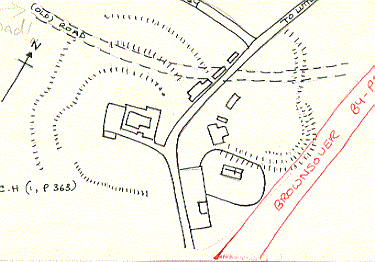
Poss Medieval Earthworks to NE of Brownsover Church
The site of several linear earthworks, banks and ditches. Few traces of the earthworks now remain but excavations during the 1950s found evidence that the features may date to the Medieval period. The earthworks were situated north of the church at Brownsover.
1 British entrenchments at Brownsover. A triple row of ‘ramparts’ or banks rising in terraces on the N and W and possibly on the S. On the E are traces of an irregular bank and ditch. A road has been recently been cut through the earthworks and various finds made (PRN 5401).
2 Recorded as a prehistoric defensive earthwork.
3 In 1629 certain aged witnesses deposed that Brownsover Park, which has been enlarged from the common fields to 30 acres, anciently contained no more than four acres, adjoining the churchyard, its old banks and ditches being still visible.
4 Excavations in 1953 (PRN 5402) indicated that these earthworks are probably Medieval.
5 There are now no earthworks here of any archaeological significance and it is doubtful if there ever were. The portion published as such on the OS 1:2500 is a field road leading to the church; other earthworks are either natural or terracing resulting from 18th century and 19th century road building/landscaping. The excavated finds are no more than might be expected from any other hamlet with a Medieval background.
6 Photos in the further information file suggest that this may have been a barrow site, now under the by-pass, at NGR 450946, 277355.
- For the sources of these notes, see the
- Timetrail record
- produced by the Historic Environment Record.


Comments
Add a comment about this page