
The abuttal boxes often list occupants over a long period of time. In some cases the word ‘formerly,’ ‘since,’ ‘ late,’ ‘now,’ or a semi-colon separates names of different periods.
When plans exist, they are referred to, but they are not included and must be viewed in the appropriate document at Warwickshire County Record Office.
One of the problems of ascribing an entry to a particular burgage plot is that in the early days many owners held more than one property, and these were often of the same size and had similar abuttals. This makes the piecing together of the ‘jigsaw’ for the 16th and early 17th century quite challenging.
This is a work in progress and as such Atherstone Civic Society cannot be responsible for any errors. The files need to be regarded as a guide to the whereabouts of the original documents and users are advised to seek it out to ensure accuracy.
Anomalies in the 1547 survey
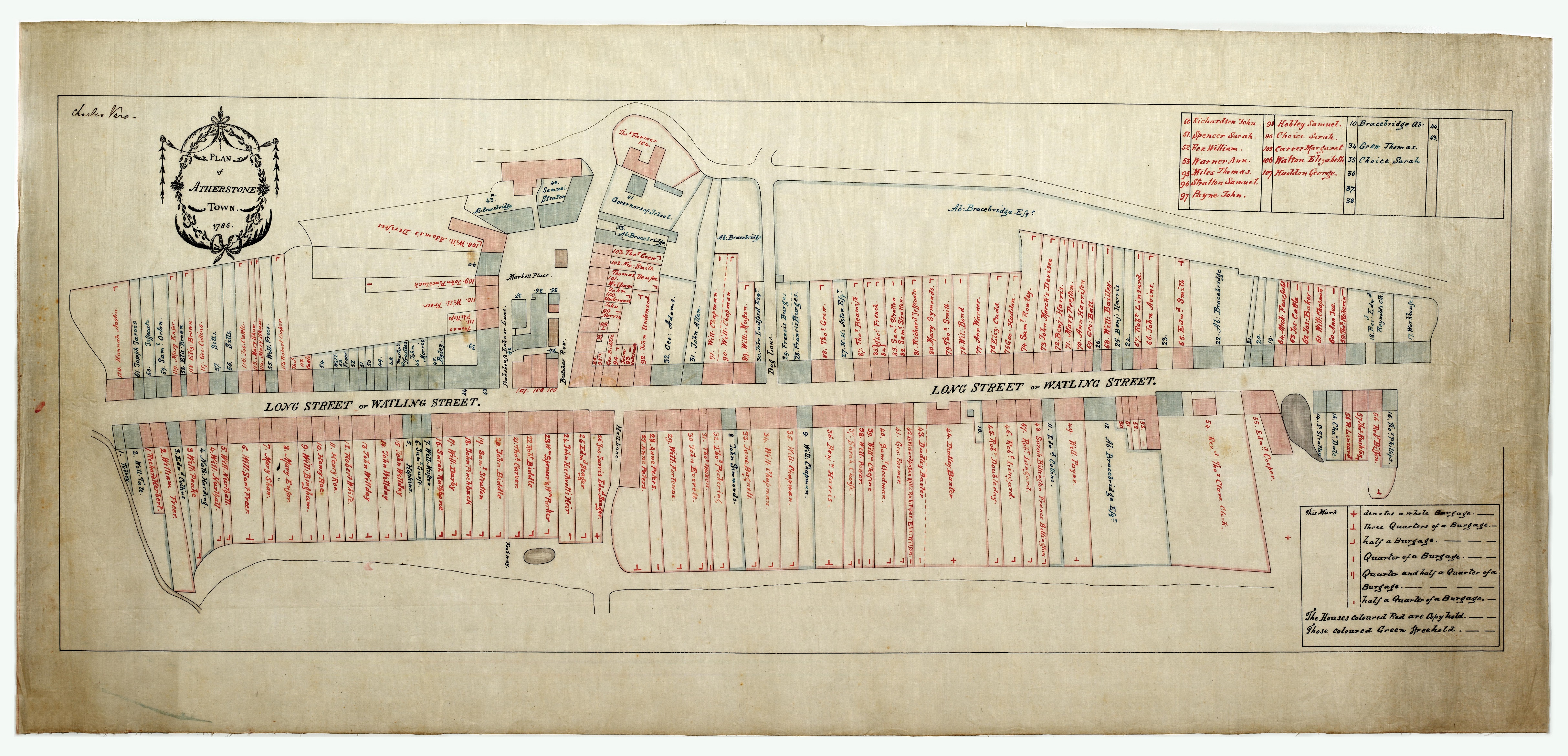
It has been relatively easy to place the burgage plots in street order, especially after it became apparent that the rents frequently remain the same in the 1661 rental. The identifications have been confused because street names are not included in the 1547 survey, and abuttals appear to cross the positions of the streets. One plot poses a specific problem. This is the burgage of John Nottingham, no. 58 on the 1547 list, on which three other properties abut (although only two abuttals are listed for it). It has become clear that John Nottingham’s burgage was located on the west corner of Long Street and Bakehouse Lane (at that time known as Derby Lane), the later F43.
What can be identified as the northern abuttal of no. 58 was a full burgage of John Rampton (no.65) which was later a property with a croft on the west side of the market square in Bakehouse Lane (F39). No. 58’s other listed abuttal (presumably to the west) is a ½ burgage of John Edwards (no.71). This appears to be C112 because the plots from C112 to C120 (including the freeholds) fit together quite neatly. It could be argued also that No 71 is one of the long series of F-tenements shown on the 1786 plan. But, if so, we have, as yet, no information to confirm this and identify which plot. If we accept that no.71 is C112, there is a problem in that the John Edward rent of 15d appeared to have reduced to 10d by 1661. This is one of several cases where the 1547 and 1661 rents do not match, so the identification is not necessarily incorrect.
Abutting to the east of no. 58 was a full burgage of Mr Lewas (no.25; the ‘garret houses’), identified above as the whole of the Long Street frontage between Butcher Row and Bakehouse Lane ( the later C105-107).
‘[ ]’ indicates doubt as to accuracy of placement


Comments
Add a comment about this page